Search Results
3
/
12
a22.jpg
Gallery could not load.
Friends of Ferry Point Park
Home
Welcome
Event Schedule
Contact
About Us
Events
Hilltop 9-11 Memorial
West Waterfront
Living Memorial Forest
Trees
East Side Trump Golf
Articles, Letters Etc.-Copy 7
Community Park @ Balcolm
Articles, Letters Etc.-Copy 4
Ferry Stop
East Waterfront Promenade
Articles, Letters Etc.-Copy 3
Volunteer Groups
Photos Events-Groups
Wildlife Critters
Articles, Letters Etc.-Copy
Oysters at Ferry Point
Articles, Letters Etc.-Copy 6
Recap of Park 2000
Articles, Letters Etc.-Copy 5
Cricket Fields
BBQ areas
Soccer Fields
Maps, Aerial Pics Etc.
History
Illegal Vehicle use
Vintage Westchester Creek
Our Network
Articles, Letters Etc.-Copy 1
H.R.R.P.
Thank You
Sports Leagues
EBCWG
Schools
BCEQ
Master Plan & Designs
Events-Neighborhood
Events-Copy 1
about-1
2017 Event Schedule-Copy
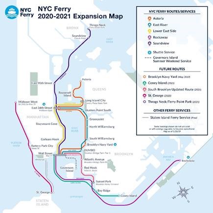
Ferry Point Park Ferry
Ferry 2
LINK TO VIDEO:
FERRY STOP AT FERRY POINT PARK...
IS HERE!
Hours of operation
By Appointment